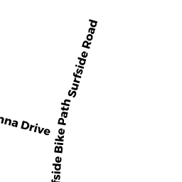
13 SURFSIDE RD
Owner Information
RYDER RICHARD C & KIMBERLEY A TRST
15 SURFSIDE RD
NANTUCKET, MA 02554


Property Details
13 SURFSIDE RD is classified as a Potentially Developable Residential Land (Vacant land).
13 SURFSIDE RD is valued at $260,700. The land is valued at $260,700 and the structures are valued at $0.
This property is in Zone R10. Confirm with local Zoning Board authorities to ensure there are no overlays or other easements on this property.
The most recent deed for 13 SURFSIDE RD is recorded at the local registrar in Book 01072, Page 0267. 13 SURFSIDE RD was last sold on Monday, March 26, 2007 for $0.
Assessment data from fiscal year 2022.
Flood Data
According to the FEMA National Flood Hazard Layer, this property does not appear to be in a flood zone. It may also be in an area not yet reviewed. Nonetheless, confirm this information prior to taking any action.
To view the flood hazards around this property, create a FEMA "Firmette" Map of the area around 13 SURFSIDE RD.
Broadband Internet Providers
| Provider | Type | Bandwidth (mbps) | |
|---|---|---|---|
| VSAT Systems, LLC. | Satellite | 2 | 1 |
| Verizon New England Inc. | DSL | 15 | 1 |
| Comcast | Cable | 1000 | 35 |
| GCI Communication Corp. | Satellite | 0 | 0 |
| HughesNet | Satellite | 25 | 3 |
| Viasat Inc | Satellite | 35 | 3 |
Broadband service provider data from December 2020.